
Essential Standard:
EEn.2.1 Explain how processes and forces affect the lithosphere.
Clarifying objective:
EEn.2.1.1 Explain how the rock cycle, plate tectonics, volcanoes, and earthquakes impact the lithosphere.
EEn.2.1.2 Predict the locations of volcanoes, earthquakes, and faults based on information contained in a variety of maps.
EEn.2.1.4 Explain the probability of and preparation for geohazards such as landslides, avalanches, earthquakes and volcanoes in a particular area based on available data
EEn.2.1.1
• Explain how various mechanisms (mantle convection, ridge push, gravity pull) drive movement of the lithospheric plates.
• Infer the relationship between the type of plate boundary and the locations of various features such as ocean trenches, mountain ranges and mid-ocean ridges. (Relate to the development of the theory of plate tectonics and geologic time.)
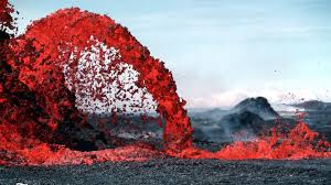
• Compare magma and lava. Locate volcanoes and relate back to plate boundaries. Explain volcanic effects on the lithosphere and relate back to plate boundaries (convergent, divergent, transform) including lahar (mud) flows and ash in the atmosphere.
• Describe the anatomy of an earthquake. Locate earthquakes – epicenter and focal point – and relate to different types of plate boundaries. Explain how the release of energy of various types of earthquakes relates to magnitude, and P and S waves.
EEn.2.1.2
• Infer the locations of volcanoes, earthquakes and faults (strike-slip, reverse and normal) from soil, geologic and topographic map studies. (Relate fault locations/types to plate boundaries.)
• Make predictions based on data gathered over time in conjunction with various maps.
EEn.2.1.4
• Conclude the best location for various types of development to reduce impacts by geohazards and protect property.
• Explain precautions that can be made to protect life from various geohazards and include meteorological hazards. Some examples include landslides, earthquakes, tsunamis, sinkholes, groundwater pollution, and flooding
EEn.2.1 Explain how processes and forces affect the lithosphere.
Clarifying objective:
EEn.2.1.1 Explain how the rock cycle, plate tectonics, volcanoes, and earthquakes impact the lithosphere.
EEn.2.1.2 Predict the locations of volcanoes, earthquakes, and faults based on information contained in a variety of maps.
EEn.2.1.4 Explain the probability of and preparation for geohazards such as landslides, avalanches, earthquakes and volcanoes in a particular area based on available data
EEn.2.1.1
• Explain how various mechanisms (mantle convection, ridge push, gravity pull) drive movement of the lithospheric plates.
• Infer the relationship between the type of plate boundary and the locations of various features such as ocean trenches, mountain ranges and mid-ocean ridges. (Relate to the development of the theory of plate tectonics and geologic time.)
• Compare magma and lava. Locate volcanoes and relate back to plate boundaries. Explain volcanic effects on the lithosphere and relate back to plate boundaries (convergent, divergent, transform) including lahar (mud) flows and ash in the atmosphere.
• Describe the anatomy of an earthquake. Locate earthquakes – epicenter and focal point – and relate to different types of plate boundaries. Explain how the release of energy of various types of earthquakes relates to magnitude, and P and S waves.
EEn.2.1.2
• Infer the locations of volcanoes, earthquakes and faults (strike-slip, reverse and normal) from soil, geologic and topographic map studies. (Relate fault locations/types to plate boundaries.)
• Make predictions based on data gathered over time in conjunction with various maps.
EEn.2.1.4
• Conclude the best location for various types of development to reduce impacts by geohazards and protect property.
• Explain precautions that can be made to protect life from various geohazards and include meteorological hazards. Some examples include landslides, earthquakes, tsunamis, sinkholes, groundwater pollution, and flooding
Key Questions
1. What causes plate tectonics?
2. Where do mountains, volcanoes, and other topographic features come from? 3. What is it like inside the Earth? 4. How do we know? 5. How do I stay safe during an earthquake? A tsunami? A landslide? A volcanic eruption? 6. How can I locate the epicenter of an earthquake? 7. How can scientists detect if an earthquake is coming? 8. How do we use topographic maps to interpret landforms? |
Criteria for Success: “I will” -Label slab-pull, ridge-push, and convection on a plate diagram,
and match them to the corresponding forces.
-Draw plate boundaries and label the landforms associated with each (continental convergence/mountains; oceanic convergence/volcanoes, trenches; continental divergence/rift valleys; oceanic divergence/ocean ridges) -Design an experiment to determine the speed of sound in materials of different density; relate this to how seismic waves move differently through different materials. -Design a public safety announcement (radio spot, visual, video, etc.) that helps the public understand what to do in the event of an emergency. -Locate an earthquake’s epicenter using seismograms and P-S travel time graph. -Compare and contrast primary, secondary, and surface waves. -Use the properties of seismic waves to explain how primary waves are used to create earthquake warning systems. -Describe changes in the shape and slope of Mount St. Helens by reading topographic maps. |
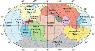
Plate Tectonics Web-Quest
|
Volcanoes & Plate Tectonics
|
Essential Vocabulary
Mantle Convection currents ridge push slab pull Magma lava Richter Scale Magnitude moment magnitude Seismic waves Primary waves Secondary waves surface Oceanic crust continental crust Ocean trench ocean ridge volcanic island arc Continental volcanic arc rift valley mountain range hot spot Convergent boundary Divergent boundary Transform Fault Boundary plate boundaries Subduction Geohazards: lahar, landslide, tsunami Epicenter Focus fault (reverse, strike-slip, normal) Landforms: Appalachian Mountains, fall zone, shorelines, barrier islands, valleys |
Performance Task
| ||